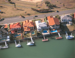
 Developments in the lower reaches of estuaries such as harbours, training walls, marinas and canal estates, together with climatic change, can affect the local patterns of waves, currents or tidal exchange. These alterations can contribute to the loss or degradation of intertidal habitats.
View a conceptual model of potential causes of a change to hydrodynamics and the condition responses observed as a result of this change.
Potential indicators
There are a number of causes and symptoms related to this stressor. The following indicators are recommended for the stressor ‘Hydrodynamics’:
Pressure indicators
Indicators of sources of changed hydrodynamics:
- Dredging acitivies in river system
- Presence of entrance modifications
- Presence of canals
- Percentage of estuarine ‘shoreline’ length modified
- Presence of original estuary length lost due to a tidal barrage
Indicators of direct pressure:
- None
Vulnerability indicators
- Mean spring tidal range
Condition indicators
Physical-chemical condition indicators:
- None
Biological condition indicators:
- None
| Possible causes | Possible symptoms |
The actions/events/situations that might induce this stress:
| The actions/events/situations that might arise from a change to the stressor:
|
Fact sheets on background science and economics
Models
Australia
The Catchment Modelling Toolkit is a repository of hydrologic modelling software intended to improve the efficiency and standard of catchment modelling. Information about the models and how to access them can be obtained from this site. This site also provides information on how to choose an appropriate model.
Dynamic Reservoir Simulation Model (DYRESM) is a one-dimensional hydrodynamics model for predicting the vertical distribution of temperature, salinity and density in lakes and reservoirs.
Interactive Component Modelling System (ICMS) provides catchment managers with a tool to develop and investigate a range of ‘what if’ scenarios for a range of complex issues important in their catchment. You can download the ICMS software and participate in the exchange of models and code as well as downloading tutorial and workshop materials.
International
Coastal Engineering Applets. This page is a listing of Java applets that might prove of use in coastal engineering. To run these applets, you only need a web browser that supports Java, such as Netscape 3.01/4.0+.
Delft 3D. Delft3Da 2D/3D integrated modelling tool for: Hydrodynamics, Waves, Sediment transport, morphology, water quality, particle tracking for water quality, ecology.
DHI Water and Environment software. DHI Australia offers a range of leading software products. These products are tools for investigation of environmental and hydraulic systems.
Environmental and Water resource software. The Scientific Software Group have developed environmental and water resource software. You can search for products based on their usefulness to a specific environmental discipline.
Hydrologic Engineering Software (HEC) has been developing computer programs for hydrologic engineering and planning analysis procedures since its inception in 1964.
USGS Hydrologic and Geochemical Models. Software and related material (data and documentation) are made available by the U.S. Geological Survey (USGS) to be used in the public interest and the advancement of science.
XP Software Modelling products designed for hydrology modelling, runoff routing, dynamic and steady state hydraulics as well as many other engineering-related applications.
ASR provides industry standard numerical modeling with a full suite of interlinked models for hydrodynamics dispersal, pollution, oil spills, plumes, sedimentation, waves, beaches, coastal management, primary production and dynamics of larvae.

