The Australian Shallow Waters Spectral Library initiates an Australia-wide, single method approach to remote sensing based habitat mapping.
A standardised spectral library
Seagrass and macroalgae are critically important in coastal environments. Spatial information, such as satellite imagery, can form the basis for quantifying:
- species richness, abundance and diversity
- biomass in a spatial context, and
- change over time.
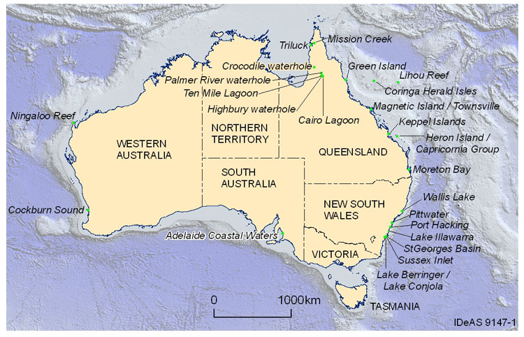
Figure 1. Locations where the substratum spectral data in the Australian Shallow Waters Spectral Library was collected. (Mouse over the location will give you the details of available databases and owner) Datasets have been available in several different formats and collected using a variety of sampling protocols. In order to replicate the accuracy of sample measurements across locations, a standardised protocol for the collection and implementation of spectral library data is important. The Australian Shallow Waters Spectral Library initiative aims to collate all existing Australian spectral library data into a single, standardised database. New data, collected via the Field Spectroradiometer Loan Service will be added to the library and freely available. The library initiative will assist Australia to better report on condition and trends in coastal habitat extent through:
- providing definitive information on spectral signals for classifying satellite images
- identifying spatial and thematic gaps and assist in fieldwork planning to effectively target and fill these gaps
- facilitating better change detection over time.
Spectral signals
To accurately interpret and classify coastal substrate features from satellite images in complex aquatic environments, spectral signatures of several substrate types existing in close proximity, have to be analysed concurrently. Spectral signals are often not representative of a single cover type but rather a combination of the cover types and thus the signals are a mix of the components making up an aquatic community. These mixed signals present a problem for accurate substrate classification. One way of overcoming this problem is to compare these mixed spectral signatures to a set of pure reference spectra, often referred to as ‘end members’, which are measured in the field or laboratory. Each substance contributes to the mixed spectral signature proportionate to the fraction of the area that is covered by that substance. In conjunction with pattern and texture image processing analysis, complemented by expert knowledge on distribution likelihood the use of pure reference spectra can be a powerful tool in shallow water benthic habitat mapping.

Figure 2. Example of unique spectral signatures, in the 400 to 900nm portion of the electromagnetic spectrum, of a number of substrates collected by CSIRO at Wallis Lake, NSW
Field Spectroradiometer Loan Service
A complementary initiative to the Spectral Library is the acquisition of two field spectroradiometers by Geoscience Australia. These are available for loan to eligible researchers across the country. One of the conditions of loan is that any spectral data collected is contributed to the Australian Shallow Waters Spectral Library to assist in building this national repository. Field spectroradiometers for calibration and validation of water quality maps from satellite imagery
Further information
- A Field Guide for Spectral Measurements of Australian Shallow benthic habitats
- ASD FieldSpec® Pro HandHeld Cookbook
Contacts
Australian Shallow Waters Spectral Library Janet Anstee or Dr Elizabeth Botha Environmental Remote Sensing Group CSIRO Land and Water Field Spectroradiometer Loan Service Dr Medhavy Thankappan Australian Centre for Remote Sensing (ACRES) Geoscience Australia

